Frequently Asked Questions
In 2003, we finally decided to start a list of questions that we have been asked more than once.
01- Who is Bizer Corporation?
02- Where did the name Bizer come from?
03- Why did Bizer start making a map?
04- Where did you get all that depth data?
05- Did you actually go out an
measure EVERY buoy and rock?
06- Why doesn't BIZER number all the buoys?
07- How often does Bizer update its map of Winnipesaukee?
08- Which lakes do you chart?
09- How do you know where all those rocks are?
10- Who is Sarahbeth?
11- Has anyone ever found a rock that you missed?
12- Why don't you have north at the top?
13- Do you support Garmin (or any handheld) GPS?
14- Could you recommend a GPS that's affordable and meets
my needs?
15- Do you support Magellan, Humminbird,
or Lowrance GPS?
16- Are any islands open to the public?
17- Why do you put FL "80" next to buoy
#80? Why don't you just put 80 without the FL, the extra
space, and the quotes? I don't need all that redundant information.
18- Is it "Sanders Bay" or "Saunders
Bay"?
19- Where did they film What About Bob? (and other stuff)
20- I'd like to name a cove (or island, buoy, rock) after
my uncle / mother / father. Would you place that name for me on the
chart?
21- Why should I purchase the Bizer electronic version of
Winnipesaukee? Garmin sells a version for less.
22- I am upgrading to a new boat and I am also going to
install a GPS. Ideally I would like a GPS that can load your maps and I can
visually see where I am on the lake while under way, just like on a car. Is
that available using your maps? If so, what GPS do I need to make this work and
what software/maps do I need to order from Bizer???
23- I'm driving north on I-93 and I'm calling you from my
cell phone. What exit do I get off at to get to Laconia?

Q01> Who is Bizer Corporation?
A> Bizer (rhymes with "geyser") is the part time venture of
Colin and Theresa Woodworth. It was started by their father in 1996 and
they have been running it since 2003.
 Q02> Where did the name Bizer come from?
A> Bizer
is one of the nicknames of the family dog, Zoe (1991-2008).
Q03> Why did Bizer start making a map?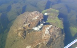
A> We were introduced to Winnipesaukee in 1991. We purchased property in the fall of 1992. In 1993, Dad (Stewart) hit a rock 800 feet east of Pistol Island and did $2400 in damages to his boat. Having been a navigator in the Coast Guard, Stewart was more than annoyed that the only navigation map showed no hazards in the area. The map maker was unconcerned. When the map maker made no effort to correct the map, we started collecting data. With a GPS, we started collecting buoy positions and depth data. Bizer published their first edition in 1996. As for the rock we hit, we've named it Bizer Rock on our chart. We find that it gets hit several times each year. The photo above shows a complete outdrive, which was found in September, 2000. Another outdrive was added in 2002.
Duncan Press has yet to put any rocks on their map within 500 feet of this location. The rock is only two inches below the surface in the fall.
Q04> Where did you get the depth data?
A> Bizer has a combination GPS and sounder that outputs position and depth to a laptop PC every 2 seconds. We have criss-crossed the lake several times. Each year, we gather more data. We currently have about 65,000 depth observations.
Q05> Did you actually go out and measure every buoy and rock with a GPS? That must have taken months.
A> Yes. We took a two GPS readings (separated by at least 15 minutes) on every buoy and rock on Bizer's chart. There are about 850 buoys in Lake Winnipesaukee. At one buoy every three minutes, that took about 50 hours which was spread out over several weekends. We did most buoys twice and averaged the readings. To keep the map current, we view every buoy each year. We take a GPS reading on about 20% of the buoys each year.
Not only do we have a catalog of every buoy, but each buoy entry contains the bearing and distance to the nearest boating hazard, the type of hazard, and its depth.
Q06> Why doesn't Bizer number all the buoys?
A> In an email dated 19-Apr-2006, the NH Marine
Patrol advised Bizer,
The MP is not numbering spar buoys. I am aware that Duncan Press numbered a Newfound Chart, however that was their
doing. We have no plans to mark spars with any numbers at this time.
In an email dated 30-Apr-2006, addressed to Bizer and Duncan Press, The
Marine Patrol said, in part,
In addition, we are not using buoy numbers except for the flashing light
buoys, and do not intend to use or mark spar buoys with numbers.
Q07> How often do you update your chart? How long does it take you to update your chart?
A> We update our chart database whenever we notice a change. All the data are kept on a PC at home. If (for example), Bizer finds a new rock, it takes about 10 minutes to add it to Bizer's database. The chart is completely regenerated after each update and then printed on our PC printer. It's checked for accuracy and then discarded. For the map that you purchase, we take our disk files to a film maker. The film maker makes new negatives for each edition. We take the five negatives (four for the front, one for the back) to a printer who can print 10,000 charts and have them on Bizer's desk within a week.
Q08> Which lakes do you chart?
A> Bizer currently charts Winnipesaukee and Winnisquam. Winnipesaukee was easy because of our own shorefront property. We rented a boat on Winnisquam for a week to gather data on that lake. At this time, we have no plans to do other lakes as we have no convenient way of putting out boat in other lakes.
Q09> How did you know where all those rocks you have on your chart?
A> We've found them, sometimes the hard way. We poked around in an outboard looking for trouble. We measured the position of each rock on our chart with GPS. We took a 12-foot long boat hook, marked it, and turned it into a 12-foot ruler. We measured the depth of each rock with our ruler. And, yes, we did hit a rock occasionally. But since we were going less than 5 MPH, our total damages were not much. We have (as of February, 2006) 674 rocks and mini-islands charted. Our nearest competition shows less than 160 rocks. We beat them 4 to 1.
A> Sarahbeth is Colin and Theresa's niece (Stewart's granddaughter). This question arises because hidden, in small print, about 2 3/4 inches north of the Wolfeboro docks is "We * Sarahbeth" with a small red heart replacing the *. If you spend any time looking at the fine print, you will find many cute sayings or amusing words such as "This Space for rent", or "Mirror Lake" printed like a mirror image or "Rattlesnake Island" in serpentine lettering. These items have no bearing on the navigation quality of the chart.
Q11> Has anyone ever found a rock that you missed?
A> Yes. It has happened three times. Each time, Bizer rewarded the finder with cash or a personalized framed chart. Bizer wants to chart all shallow areas less than six feet deep. To that end, Bizer offers a reward to anyone who finds a shallow area that we overlooked.
Q12> Why don't you have north "up"?
A> To save space and cost. Excluding borders, the lake on Bizer's chart is 21"x32", about 4.7 square feet. A north up chart at the same scale would be 26"x30", about 5.4 square feet. This larger size would add at least 15% to the retail price.
Q13>Do you support Garmin (or any handheld) GPS?
A>A qualified Yes. For 2008, Bizer is releasing the second version of its Winnipesaukee chart for Garmin. This is a "beta" version that was developed over the 2007-2008 winter. It has not been tested in the field. While substantially better than our 2007 Garmin version (G1), the C-Map version has slightly more functionality than Bizer's Garmin G2 version. Go to http://bizer.com/garmin for the latest progress on Bizer's Garmin project.
Q14> Would Bizer recommend an affordable GPS that has great detail of Lake Winnipesaukee?
Answer: Not really
- We do not have in-depth knowledge of GPS
receivers. We only purchase one when we need a feature that we don't
already have.
- We haven't bought a GPS in a while. We're sure
things have change substantially.
- What's affordable to one person may be prohibitive to
another. What's your budget?
- Great detail is subjective. The best lake detail
at this time is C-Map chips and/or Bizer's data for Garmin GPS.
Others go down from there, but they may be adequate for your needs.
For example, Garmin's Roads & Recreation database, when
added to Bizer's list of waypoints around the lake, may be adequate for
your needs.
- Do you want a portable or fixed mount? A portable
usually has a small screen. A fixed mount device can't be moved to
your car.
- Some people demand a color screen. Bizer doesn't
care. Black & White screens are less expensive, draw less power,
and may be easier to see in sunlight.
GPS is not Bizer's primary means of navigation. Our eyes are. However, we have eight GPS's. One can assume these were our GPS's of preference at the time of purchase:
- In 2014, we purchased a Garmin Montana. It is a
bit large for being portable, but we like it. It has a stand so it
can fit on the dashboard. It is battery operated, but it also can be
plugged into a cigarette lighter;
- In the fall of 2009, Bizer purchased a Garmin Nuvi, 750W. We've loaded it with Bizer's
data, but we've never used it on the water (we prefer our 276C on the
water).
- In 2007, Bizer purchased a Garmin 76 cSX so that it could test our Garmin map on a GPS
that had a MicroSD chip. It works,
but has a small screen.
- In 2006, Bizer purchased its first color GPS, a Garmin
276C. Bizer is developing a color map of Winnipesaukee for
Garmin GPS. We needed one to see how the chart appeared. This
is the GPS that we use most frequently on Winnipesaukee.
- 2002 - Bizer has Standard Horizon 150 with a
C-Map chip. It works fine, but it's not portable. It's
fastened to our boat and we can't use it in a car. This model is no
longer made, but they make newer models. All comments about Standard
Horizon GPS's (from users) have been positive.
- 2004 - Bizer purchased a Garmin V which we
primarily use for driving. We've loaded it with our Garmin
map. It appears to work. However, we don't use it on the lake
because of its small screen.
- 2001 - I have a 2001 Garmin 176. It was
one of the first GPS's with WAAS. This provides better accuracy when
I'm measuring buoys and it has a bigger screen than the Garmin V. It's semi-portable and battery operated.
- 2000 - Bizer's boat is also equipped with a Garmin
185 sounder. This is what Bizer uses to gather depth data.
This device has been superseded by the Garmin 188 which has WAAS
capability.
- 1996 - Bizer also has a 1996 Trimble Scout which
doesn't have graphics. It works just fine for displaying position
and speed.
Although
most of Bizer's GPSs are portable, we have received a lot of positive feedback
about Standard Horizon dash mounted units (using the C-Map chip) as well as
Garmin's 400 & 500 series dash mounted chartplotters using the Bizer chip.
Personally, I think it all comes down to whether a GPS has the features that
you want at a price that you're willing to pay.
Q15> Do you make a chart for Magellan, Humminbird, or Lowrance?
A> Not directly. Navionics of Wareham, Masshachusets, has licensed Bizer's map and they do produce a chart for Magellan, Humminbird, and Lowrance. Bizer has not seen one of their chips since 2009. Bizer suggests that you contact them at www.navionics.com or call them at 800-848-5896.
Q16> Which islands are open to the public?
A> No islands are publicly owned. Five Mile Island and Ragged Island are owned by the Lakes Region Conservation Trust. You need their permission to land on those islands. The northern half of Stonedam Island has a public hiking trail. The trail is accessible from a pier on the northeast corner (near the words "Wildlife Preserve" on Bizer's chart inset). Just about everything else is privately owned.
Q17> Why do you put FL "80" next to buoy #80? Why don't you just put 80 without the FL, the extra space, and the quotes? I don't need all that redundant information.
A> Once you've seen two or three lighted buoys on Winnipesaukee, you know they're all the same. They all flash at night and they all have their number printed on them. However, a first-time boater doesn't know that. The FL tells them it's a flashing buoy. The writing within quotes tells them what is written on the buoy. A good example is light #56 which has "56 NO WAKE" written next to it. Not only is 56 written on the buoy, but NO WAKE is also written on the buoy. We try to follow the standards as set forth in the Nautical Chart Manual published by the National Ocean Service.
Q18> Is it Sanders Bay or Saunders Bay?
A> Our unofficial answer is Sanders. In 1994 we asked the same question. We were told that many years ago, someone opened up a motel near Dockham Shore Road. They named it the Saunders Bay Motel because that's what they thought it was. Over the years, the bay's spelling evolved to Saunders. The motel went out of business in the 80's and the spelling gradually reverted to Sanders. According to Mrs. Fay (I think that's who Bizer spoke to), the state legislature passed a law naming it Sanders. Nobody has ever come up with a more definitive answer so it's spelled Sanders on Bizer's chart.
Q19> Where did they film What About Bob (1991) with Bill Murray and Richard Dreyfus?
A> The story takes place at Lake Winnipesaukee in August. We know it looks like New Hampshire, but What About Bob was filmed at Smith Mountain Lake in Virginia. Filming was scheduled for September/October when Winnipesaukee leaves would be yellow/orange. The time setting for the film was August.
Bizer has started to compile a list of pop-culture references to the Lakes Region.
Q20> I'd like to name a cove/island/buoy/rock after my uncle/mother/father. Would you place that name for me on the chart?
A> We can not. Bizer's chart reports names; it does not create them. Bizer only reports names taken from a generally accepted public record, and then only if the name has some navigational significance to it. Bizer receives 3-5 requests a year in which people want to name something in honor of a family member/friend. If Bizer honored these requests, the number would jump to thirty. Pretty soon, the entire chart would become cluttered with names.
Q21>Why should I purchase Bizer's electronic map of Winnipesaukee? Garmin sells a version for much less.
A> The quick answer is that you get what you pay for. If your objective is to keep from getting lost, then Garmin's data will work just fine for you. Bizer's claims to fame are accuracy and precision. Bizer shows rocks where others do not. Bizer's buoy positions are typically within thirty feet while many of Garmin's buoys are off by one hundred feet or more. Also, Bizer updates its chart frequently. Here are just a few of the features on Bizer's version that are not on Garmin's version:
- North of light #29, Bizer shows several rocks and a
"no passage" symbol. Garmin shows no rocks and the water
depth to be more than 10 feet.
- Bizer shows six pairs of buoys in the Graveyard.
Garmin (and Duncan Press) show five pairs. The sixth pair was added
in 2003.
- Bizer shows four red-and-white buoys south/east of Fish
Island. The fourth buoy, added in 2006, is shown by neither Garmin
nor Duncan Press. Both Garmin and Duncan show the depth to be in
excess of 12 feet at this location.
- 800 feet east of Pistol Island is a rock less than one
foot below the surface. This rock has been shown on Bizer's chart of
Winnipesaukee since 1996. Garmin shows the depth to be 14 feet at
this point.
- Northeast of Hen Island are many rocks that Bizer has
marked while Garmins shows a depth over 10
feet. Bizer shows four black-and-white buoys in this bay (the fourth
was added in 2003) while Garmin only shows three black-and-white buoys.
- In Langdon Cove at the southern end of Moultonborough
Bay, Bizer shows a bouy that was added in 2005
while Garmin does not. Where Bizer shows a rock, Garmin indicates a
depth of 34 feet.
- Light #46 sits atop a rock that sticks four feet above
the surface. Garmin shows that rock to be 480 feet east of light #46.
- At Umbrella Point on Wolfeboro Neck, Bizer shows a buoy
that was added in 2005. Garmin shows neither the buoy nor the rock
that has appeared on Bizer's chart since 1996.
Q22>I am upgrading to a new boat and I am also going to install a GPS. Ideally I would like a GPS that can load your maps and I can visually see where I am on the lake while under way, just like on a car. Is that available using your maps? If so, what GPS do I need to make this work and what software/maps do I need to order from Bizer???
A>There are so many options that Bizer has not tested them all. In most cases, we rely on comments from users.
- C-Map (a.k.a. Jeppesen Marine) has licensed Bizer's map
for their C-Map chips that fit into a variety of GPS chartplotters.
See the C-MAP web site. You
would need a chartplotter that takes the C-MAP MAX-Lakes-East. While
there are many chartplotters that take the C-MAP cartridge (about $135),
chartplotters by Standard Horizon are the most frequently talked-about on
the Winnipesaukee Forum. Bizer has heard
nothing but praise for Standard Horizon chartplotters and C-Map data chips
of Winnipesaukee. The only drawback for C-MAP chips is that (to the
best of Bizer's knowledge), you must have a chartplotter installed in your
boat; there are no GPS devices that you can use in your car, as
well.
- Garmin: Garmin manufactures a lot of GPS devices.
Some Garmin devices are designed for boats and dash-mounted (like the
Standard Horizon mentioned above), some devices are portable, some devices are designed for automobile use
only. Garmin did not want to license Bizer's map, so, with the
assistance of others, Bizer developed it's own map of Winnipesaukee for Garmin.
See the Bizer's Garmin page.
- Navionics: - Navionics
has licensed Bizer's data for their chips. Navionics
chips work in Magellan and Lowrance
devices. Bizer has not seen a Navionics
chip since they licensed Bizer's data.
- iPad - By arrangement with
Brad Goodman, Bizer's chart is now available for iPhone, iPod touch, and iPad provided that you have iOS
4.2 or later. For details, go to Brad's
web page
- For your PC: By using (A) A GPS that outputs NMEA data
(most do, we used a Garmin) connected to (B) a laptop loaded with (C) a
mapping software (We used OziExplorer) and (D) a
PDF version of Bizer's chart ($25), we were able to putter around the lake
with our laptop.
- The back of Bizer's waterproof chart lists 200+
waypoints around the lake. One can manually enter waypoints into a
GPS and go from waypoint-to-waypoint around the lake.
Q23 - OK, so these really aren't frequently asked. We thought we would share some of the off-the-wall questions that we have been asked over the years.
- I'm driving north on I-93 and I'm calling you from my
cell phone. What exit do I get off at to get to Laconia? (Ans=Exit 20)
- I live in Fitchburg. How do I get to the boat
launching area on State Landing Road in Moultonborough?
I
If at first
you don’t succeed, maybe skydiving isn’t for you. 781-267-5187 six out of seven dwarfs are not
Happy 508-287-8004 Leaning
tower of Pizza > (781) 492 9362