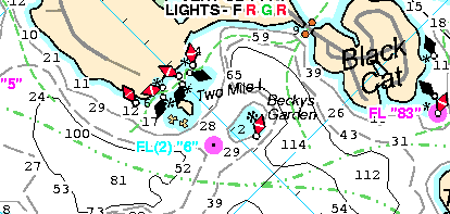
It's just like navigating on any other body of water.
Navigating on Lake Winnipesaukee
is just like navigating on the ocean or any other body of water.
That's why we designed our chart to emulate the charts of the
National Ocean Survey (NOS).
-
Only Bizer color
codes areas less than six feet deep. Since Bizer's first chart in 1996,
only three people have shown us a shallow area
that we overlooked. In order to find (and chart) all shallow areas,
Bizer offers a
reward of $150 to $250 to anyone who can disclose a shallow area (less than 6 feet deep)
that Bizer overlooked. Shallow areas are important for you to avoid so we want to show all of them.
- Our competition boasts, "The most complete and accurate charts of
the lakes yet! We GUARANTEE it!"
(their capitalization and punctuation).
Bizer backs up its digital charts with cash rewards for finding Bizer omissions.
Their "guarantee" is that they will replace their chart.
- Only Bizer's charts are being used by C-Map and Maptech for electronic
versions of Lake Winnipesaukee. Only Bizer's
data is precise enough for GPS.
- Like all harbor, lake, and river charts published
by the National Ocean Service (U. S. Department of Commerce), Bizer's charts use a Mercator
Projection, the standard for marine use. A
Mercator projection is different from a Transverse Mercator projection which
others use.
-
Only Bizer has
enlarged insets in complex places to show greater detail.
-
Bizer has been within 10 feet of each buoy and rock
that is depicted on our chart.
We measured the position of each with GPS.
Bizer's standard is that bouys and rocks must be charted within
40 feet (0.3 mm on Bizer's chart) of their true position.
Their "standard" is that buoys must be charted within
528 feet (5.0 mm on their chart) of their true position.
- Bizer's depths are based on the interpolation of over 65,000 depth
observations. Other charts are based upon fewer than 120 depth
observations.
- Bizer shows 683 rocks on
its eighth edition chart. Our nearest competitor shows less than 180.
- The back of Bizer's standard chart has over 250 waypoints including
latitude and longitude. The position of all lighted buoys is
given. Enlargements of public docking areas shows boating services
including places to eat. These features are not on any other
chart.


